
How To: Transfer Routes from Navionics App or Google Earth to Chartplotter
 Willhound
Member Posts: 4,240 ✭✭✭✭✭
Willhound
Member Posts: 4,240 ✭✭✭✭✭
It took me a bit of hunting around to find the following info, maybe others will find it useful. Many of us are using the Navionics app as a planning guide and/or GPS/Chartplotter back up, but even without it this method works with Google Earth also. Higher end touch screen Chartplotters make creating a route easier, but many others, like mine require a very time consuming and labourious process of picking individual waypoints and adding them one at a time to the route. Navionics does allow direct transfer to Raymarine plotters, but not any others at this time, so here's how to do it.
Navionics App:
1) From main map screen touch the Route Button, Manual, create your route, activate it, hit "Route" button again, "Detail" and at the top right of the screen is a little button to export a route (looks like a little box with an arrow.Or if you already have a route in Navionics the same applies. Use this to send the route to a PC. It will send it as a .kmz file which is a Google Earth format. I usually just e-mail it to myself.
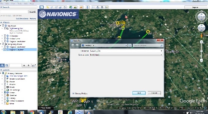
2) Open the file in Google Earth. In the dialogue menu on the left of the screen, right click on the name of the .kmz file and choose "Save Place As" and save it under the .kml option to a folder that is easy to find (I just saved to Desktop)
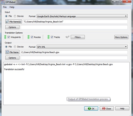
3) Go here https://www.gpsbabel.org/ this is a freeware program that converts map and gps formats.
Pay attention, do NOT click on the first big green button, it's a stupid embedded ad link. Look down a bit and you'll see a button that says "GPSBabel Free Download". Download and install the program to your PC.
Use GPSBabel to convert the .kml file you saved to a .gpx as per the screenshot:
The resulting .gpx file (a format that most GPS' and plotters can read) can be saved to an SD card or transferred to your plotter via cable or whatever means you have to import data if your plotter accepts raw .gpx files. Most companies have a software that allows you to transfer .gpx direct or convert to the native format of the plotter. In my case it is Humminbird PC. Garmin also has one called Garmin Express etc. The route should now be accessible.
Google Earth:
If you do not use the Navionics app you can accomplish the same thing with Google Earth directly. The steps are all the same except you create a "Path" in Google Earth and then follow steps 2 and 3 above. There is also a Youtube video here: https://www.youtube.com/watch?v=870LqaEm_Uc
This video is specific to my Humminbird, but the starting steps of creating the path in Google Earth, and converting it in GPSBabel would be the same for any brand. If you search there are all kinds of videos for the different GPS manufacturer's. As always, be careful, a lot of them are pushing paid versions of websites or software to do the .gpx conversion. I find GPSBabel to be easy and it's free. When you close the program a window will pop up asking if you want to donate, but totally optional.
Sounds complicated, but once you've done it a few times you can create and transfer a route in a couple of minutes.
Navionics App:
1) From main map screen touch the Route Button, Manual, create your route, activate it, hit "Route" button again, "Detail" and at the top right of the screen is a little button to export a route (looks like a little box with an arrow.Or if you already have a route in Navionics the same applies. Use this to send the route to a PC. It will send it as a .kmz file which is a Google Earth format. I usually just e-mail it to myself.
2) Open the file in Google Earth. In the dialogue menu on the left of the screen, right click on the name of the .kmz file and choose "Save Place As" and save it under the .kml option to a folder that is easy to find (I just saved to Desktop)
3) Go here https://www.gpsbabel.org/ this is a freeware program that converts map and gps formats.
Pay attention, do NOT click on the first big green button, it's a stupid embedded ad link. Look down a bit and you'll see a button that says "GPSBabel Free Download". Download and install the program to your PC.
Use GPSBabel to convert the .kml file you saved to a .gpx as per the screenshot:
The resulting .gpx file (a format that most GPS' and plotters can read) can be saved to an SD card or transferred to your plotter via cable or whatever means you have to import data if your plotter accepts raw .gpx files. Most companies have a software that allows you to transfer .gpx direct or convert to the native format of the plotter. In my case it is Humminbird PC. Garmin also has one called Garmin Express etc. The route should now be accessible.
Google Earth:
If you do not use the Navionics app you can accomplish the same thing with Google Earth directly. The steps are all the same except you create a "Path" in Google Earth and then follow steps 2 and 3 above. There is also a Youtube video here:
https://www.youtube.com/watch?v=870LqaEm_UcThis video is specific to my Humminbird, but the starting steps of creating the path in Google Earth, and converting it in GPSBabel would be the same for any brand. If you search there are all kinds of videos for the different GPS manufacturer's. As always, be careful, a lot of them are pushing paid versions of websites or software to do the .gpx conversion. I find GPSBabel to be easy and it's free. When you close the program a window will pop up asking if you want to donate, but totally optional.
Sounds complicated, but once you've done it a few times you can create and transfer a route in a couple of minutes.
"Knot Quite Shore" - 2000 FV270 (Sold)
2018 Cherokee 39RL Land Yacht (Sorry...)
2018 Cherokee 39RL Land Yacht (Sorry...)
Comments
One other thing I should mention ( when I'm back on on my PC I'll edit the post above) is that a .gpx file is just a database of waypoints. You need to use the software for your GPS to convert them into a route first and send that to the plotter. Otherwise you're back to square one picking through them one at a time.
2018 Cherokee 39RL Land Yacht (Sorry...)
Most of the plotter transfer programs are free if you register the unit, some are paid. But there are other third party freewares out there that will sometimes do it.
I also discovered that although my Humminbird is about 4 years old, no one had ever registered it, so I did, and am now being treated to a 1 year free Navionics + membership/upgrade.
2018 Cherokee 39RL Land Yacht (Sorry...)
2018 Cherokee 39RL Land Yacht (Sorry...)
2002 FV 342 on Lake St. Clair - Past Commodore SHC - Vessel Examiner USCGAUX
2018 Cherokee 39RL Land Yacht (Sorry...)
It's pretty easy to display charts in Google Earth. You can download them free from NOAA. Here's a page with instructions:
https://www.nauticalcharts.noaa.gov/csdl/seamlessraster.html
2002 FV 342 on Lake St. Clair - Past Commodore SHC - Vessel Examiner USCGAUX
2018 Cherokee 39RL Land Yacht (Sorry...)
EDIT: Just tried it and works great!. In fact, now no need to import into Google Earth. Just "Share" the route via e-mail to yourself. Navionics will show that it is exporting as a .png file but don't worry about it. In the e-mail there will be two links, one to view, one to download. Choose download. It will download as a .kml file. Use GPSBabel (or similar) as per in the instructions above and convert it to .gpx and you're good to go.
2018 Cherokee 39RL Land Yacht (Sorry...)